







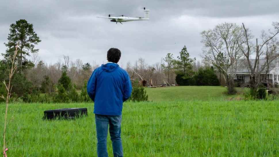
After deadly tornadoes struck the Southeast in March, researchers at the National Oceanic and Atmospheric Administration (NOAA) used remote-controlled, unmanned aircraft for the first time to successfully capture aerial footage of storm damage from hard-to-reach locations.
Related: DroneWaves: From pharmaceuticals to pizza, how drone use could evolve
The new imagery helped the community’s response and recovery efforts, and it allowed forecasters to more accurately map the paths of destruction from multiple tornadoes. For example, they were able to identify the beginning of an 80-mile tornado track in a remote area near a river with limited road access.
Scientists hope images from the drones will improve their understanding of tornadoes and lead to better forecasts.
A team from the NOAA National Severe Storms Laboratory (NSSL), in collaboration with the Cooperative Institute for Mesoscale Meteorological Studies (CIMMS) at the University of Oklahoma, deployed the two drones following tornado outbreaks on March 17 and March 25. Most of the tornadoes struck in Alabama.
Keli Pirtle, with NOAA media relations, told FreightWaves that the Quantum Trinity F90+ and Skydio2 quadcopter are research drones. Because NOAA wants to continue testing them, there’s no plan to purchase more anytime soon.
“This is research to prove the concept,” Pirtle said. “That’s as far along as they are right now.”
The drones’ speciality cameras provide researchers with extremely high-resolution images, including information not visible to the human eye. The multispectral cameras have two additional bands — red Edge and near Infrared — that collect information on vegetation.
“So based on the response the researchers see in those bands, they’re able to better see where the damage has occurred and the magnitude of damage to vegetation, which can help them better assign the rating associated with storm intensity,” Pirtle explained.
Storm damage and vegetation stress can be underestimated, and drones provide a more complete picture for rural areas. Better observations of these impacts may lead to an improved understanding of the relationship between what forecasters see on Doppler radar and the actual strength of a given tornado.
Pirtle added that NOAA also has two DJI systems (Matrice 210) drones, but hasn’t used them yet because of some uncertainties in federal regulations.
Related: DroneWaves: UPS takes aggressive approach with drone airline
Forecasters with NOAA’s National Weather Service (NWS) office in Birmingham, Alabama, are excited about the potential for using aerial images for post-storm damage surveys in heavily wooded and sometimes inaccessible rural areas.
“This imagery could be a huge benefit to our office as we will be able to provide more detailed documentation of these impacted areas to other core partner government agencies,” Alex Sizemore, a meteorologist at the NWS Birmingham office, told NOAA. “It also would allow us to get the information much more quickly, saving us time.”
Click here for more FreightWaves articles by Nick Austin.
You might also like:
Coast Guard coordinates cleanup after deadly SEACOR Power capsizing
Logistics groups ready to help during potentially busy hurricane season
Brokerage Compliance Symposium
The day before F3. Every compliance issue you face - fraud exposure, carrier liability, FMCSA rules, cargo theft, insurance gaps - navigated by attorneys and operators defining best practices in a changing industry.
F3 Awards Dinner
The night before F3. FreightTech100 companies honored. FreightTech 25 and Shipper of Choice winners revealed live. Cocktail reception into dinner and live music - 300 industry leaders in one purpose-built room.
F3: Future of Freight Festival
Industry-defining keynotes, rapid-fire technology demos, and industry leaders networking in experiences across Chattanooga - plus the inaugural F3 Awards Dinner featuring the FreightTech and Shipper of Choice reveals.
The day before F3. Every compliance issue you face - fraud exposure, carrier liability, FMCSA rules, cargo theft, insurance gaps - navigated by attorneys and operators defining best practices in a changing industry.
The Signal at Chattanooga Choo Choo • Chattanooga, TN Register NowThe night before F3. FreightTech100 companies honored. FreightTech 25 and Shipper of Choice winners revealed live. Cocktail reception into dinner and live music - 300 industry leaders in one purpose-built room.
The Signal at Chattanooga Choo Choo • Chattanooga, TN Register NowIndustry-defining keynotes, rapid-fire technology demos, and industry leaders networking in experiences across Chattanooga - plus the inaugural F3 Awards Dinner featuring the FreightTech and Shipper of Choice reveals.
The Signal at Chattanooga Choo Choo • Chattanooga, TN Register Now