




Update as of 7 p.m. Wednesday
Hurricane Ian continues to pummel Florida with torrential rains and winds as it tracks across the state, but the storm has started to weaken.
On Wednesday evening, the National Hurricane Center (NHC) reported that the latest winds were around 125 mph — a Category 3 storm — down from the 155 mph Category 4 it was when it began lashing the Gulf Coast.
The NHC in its statement said that a National Oceanic and Atmospheric Administration service station near Fort Meyers reported a storm surge of more than 7 feet.
The storm is expected to continue weakening as it tracks further inland.
As of 7:30 p.m., more than 1.6 million people in Florida were without power.
Update as of 4 p.m. Wednesday
The National Hurricane Center said the eye of Hurricane Ian made landfall in Cayo Costa, Florida, just after 3 p.m. Wednesday as a Category 4 storm with winds of 150 mph.
Ian battered the barrier islands of Sanibel and Captiva before hitting mainland Florida. As of 6:40 p.m., more than 1.5 million Floridians were without power. That number was expected to grow as the storm continues its path.
So far, some of the strongest wind gusts have occurred in the southeast quadrant of the storm, with a gust of 112 mph recorded in Naples, Florida. Naples has also set a record for storm surge with water peaking at 6.18 feet. Additional surge of up to 18 feet is expected for portions of southwest Florida.
Hurricane Charley made landfall as a Category 4 storm in this exact spot in 2004, but Ian came onshore significantly stronger as its eye was almost double the size of Charley’s. Ian already has been ranked as the fifth strongest hurricane to hit the United States.
Ian was still moving slowly to the northeast at 9 mph as of 4 p.m. Wednesday. The flood threat from rainfall is just beginning, with 12 inches to 15 inches of rain expected just to the southeast of Tampa.
Joshua Feldman, WeatherOptics’ chief meteorologist, joined FreightWaves NOW Wednesday morning to give his assessment of what to expect the next few days.
Update as of 8 a.m. Wednesday
Hurricane Ian, a strong Category 4 storm with wind speeds up to 155 mph, took an eastward turn and began coming ashore around Fort Myers, Florida, late Wednesday morning.
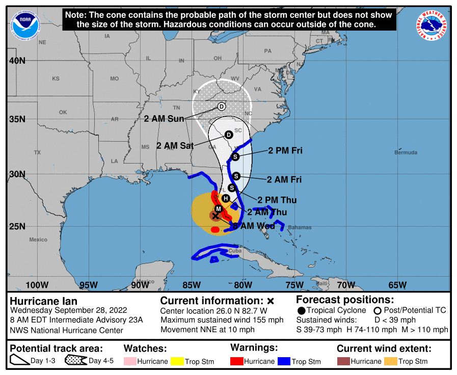
The latest reconnaissance from the National Oceanic and Atmospheric Administration Hurricane Hunters showed Ian moving north by northeast at a slow speed of 10 mph.
Life-threatening storm surge is expected to slam the Fort Myers area as well as neighboring barrier islands, including Sanibel and Captiva. The storm is forecast to slow as it comes onshore, leading to stronger inland surge.
Tampa may have escaped the worst of the storm surge with expected surge down to 4 feet to 6 feet, but that area of the Gulf Coast is still in the bull’s-eye of heavy rainfall, with 15 inches to 20 inches of rain over the next two days forecast. The urban flooding threat in Tampa is very high because of that excessive rainfall.
Even though Ian is making landfall on the southwest Florida coast, residents all across the peninsula should be prepared for hurricane-like conditions as the wind field is very wide with this storm and the impacts from rain will be felt across the entire state.
“If you are in any of those counties [in the path], it is no longer possible to safely evacuate,” Florida Gov. Ron DeSantis said during a press conference early Wednesday. “It’s time to hunker down and prepare for this storm.”

More Hurricane Ian coverage
Supply chain effects from Hurricane Ian could linger for weeks
Ports, carriers prep for disasters — everything from hurricanes to fires
FEMA’s initial Hurricane Ian prep: Lots of water and meals to move
DeSantis lifts Florida’s trucking restrictions as Hurricane Ian approaches
Brokerage Compliance Symposium
The day before F3. Every compliance issue you face - fraud exposure, carrier liability, FMCSA rules, cargo theft, insurance gaps - navigated by attorneys and operators defining best practices in a changing industry.
F3 Awards Dinner
The night before F3. FreightTech100 companies honored. FreightTech 25 and Shipper of Choice winners revealed live. Cocktail reception into dinner and live music - 300 industry leaders in one purpose-built room.
F3: Future of Freight Festival
Industry-defining keynotes, rapid-fire technology demos, and industry leaders networking in experiences across Chattanooga - plus the inaugural F3 Awards Dinner featuring the FreightTech and Shipper of Choice reveals.
The day before F3. Every compliance issue you face - fraud exposure, carrier liability, FMCSA rules, cargo theft, insurance gaps - navigated by attorneys and operators defining best practices in a changing industry.
The Signal at Chattanooga Choo Choo • Chattanooga, TN Register NowThe night before F3. FreightTech100 companies honored. FreightTech 25 and Shipper of Choice winners revealed live. Cocktail reception into dinner and live music - 300 industry leaders in one purpose-built room.
The Signal at Chattanooga Choo Choo • Chattanooga, TN Register NowIndustry-defining keynotes, rapid-fire technology demos, and industry leaders networking in experiences across Chattanooga - plus the inaugural F3 Awards Dinner featuring the FreightTech and Shipper of Choice reveals.
The Signal at Chattanooga Choo Choo • Chattanooga, TN Register Now